Île de la Cité, berceau de Paris, 1000 ans d'histoire sur 22 ha
L’Île-de-la-Cité est considérée comme le cœur historique, administratif et judiciaire de Paris. Depuis le IIIe/Ve siècle, l’Île-de-la-Cité incarne le pouvoir royal, judiciaire et religieux. La ville médiévale, insalubre et délabrée, ne fut rasée qu’à la fin du XIXe siècle, lors des grands travaux du baron Haussmann. Il ne subsiste aujourd’hui qu’un passé grandiose concentré sur quelques centaines de mètres, ce qui rend la visite pratique et aisée.
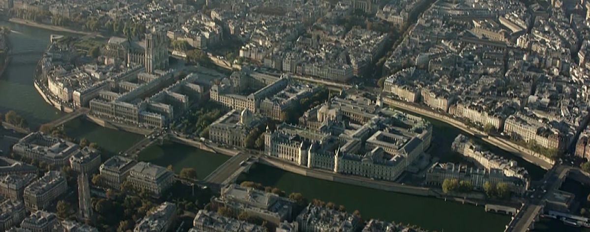
L’Île-de-la-Cité aujourd’hui
L’Île-de-la-Cité est une île située sur la Seine, en plein cœur de Paris. Considérée comme le berceau antique de la ville, autrefois appelée Lutèce, elle appartient aux 1er et 4e arrondissements. Dès 1190, le chroniqueur Gui de Bazoches la qualifiait déjà de « tête, cœur et moelle de Paris ».
L’Île-de-la-Cité ne couvre qu’environ 22,5 hectares (55 acres américains). Au 1er janvier 2016, elle comptait 891 habitants.
Une île minuscule, un destin grandiose
Anciennement Lutèce, l’Île-de-la-Cité est le plus vieux quartier de Paris.
En elle-même, elle regroupe un nombre de sites incontournables et proches les uns des autres, ce qui facilite leur visite : le Pont Neuf, Notre-Dame-de-Paris, le Pont de l’Archevêché et quelques dizaines d’autres. Grâce à sa position centrale privilégiée, entre le Châtelet au nord et Saint-Germain-des-Prés au sud, l’Île-de-la-Cité est véritablement le carrefour central de la capitale. Flânez le long des quais et découvrez la façade de Notre-Dame-de-Paris ainsi que les lumières des ponts sur la Seine. Admirez les alentours : des musiciens improviseront quelques morceaux pour distraire les passants. L’Île-de-la-Cité est aussi l’endroit idéal pour pique-niquer au bord de l’eau et profiter de l’euphorie des nuits d’été.
Aujourd’hui, l’Île-de-la-Cité est en grande partie occupée par le Palais de Justice de Paris, qui abrite la Sainte-Chapelle d’un côté et la Conciergerie de l’autre. Seule une petite partie des tribunaux s’y trouve encore (le reste ayant été transféré au nord-est de la capitale). À quelques centaines de mètres, Notre-Dame-de-Paris est en reconstruction.
(Voir la carte de 1862 ci-dessus. L’ancienne rue de la Barillerie correspond aujourd’hui au boulevard du Palais.) Mais bien d’autres choses méritent d’être découvertes dans son périmètre (mais la plupart…
La naissance de Lutèce au Ier siècle apr. J.-C.
Le nom de « cité » renvoie aux limites fortifiées de Paris à la fin de l’Antiquité, réduites à l’île seule, qui constituaient le noyau urbain de la ville médiévale.
En 52 av. J.-C., après la victoire de Jules César sur Vercingétorix (un chef gaulois), naquit Lutèce. Les Gaulois s’installèrent sur l’île et continuèrent à vivre de la rivière, par la pêche et la navigation, tandis que la ville gallo-romaine se développait sur la rive gauche.
Au début de notre ère, une enceinte dédiée à la gloire de Jupiter existait sur l’île, probablement construite par les Nautes, une riche corporation de navigateurs. En aval de l’île fut également édifié un palais où résidait le représentant de Rome.
Et l’histoire se poursuit sur l’Île-de-la-Cité
Après l’éclat de la période du Haut-Empire, les premières invasions barbares, dès 276, contraignirent les habitants de Lutèce à se réfugier régulièrement sur l’île. Plus facile à défendre, elle offrait un refuge tandis que les hordes ennemies ravageaient la Haute-Lutèce.
Lors d’une vague de Huns menée par Attila, la population de la rive gauche, galvanisée par sainte Geneviève, afflua vers l’île. Au milieu du IXe siècle, une enceinte de deux mètres de large fut construite à une trentaine de mètres des berges de la Seine.
En 508, Clovis, roi des Francs, fait de Paris la capitale de son royaume et s’installe dans le palais du ancien gouvernement romain. Avec la christianisation, les églises se multiplient sur l’île. L’ancien temple gallo-romain est remplacé entre 511 et 558 par une grande basilique chrétienne dédiée à saint Étienne, la cathédrale Saint-Étienne de Paris, sur l’emplacement de l’actuelle cathédrale Notre-Dame de Paris.
Le siège du pouvoir royal et épiscopal
Pendant la période des rois carolingiens, de 752 à 987, la vie de la capitale se concentre sur l’île. Mais à partir de Charlemagne, la ville perd son statut de capitale, la cour se déplaçant de ville en ville.
Pillée, incendiée et ravagée par les Normands à trois reprises, en 845, 856-857 et 861, elle est affaiblie. Charles le Chauve, en 877, ordonne la restauration et le renforcement de l’enceinte gallo-romaine. Deux grandes tours, le Petit et le Grand Châtelet, sont également construites pour protéger l’accès aux ponts, dont les piles sont resserrées pour mieux contrôler le passage des navires.
Lorsque sept cents drakkars et quarante mille Vikings, menés par Sigfried, arrivent sur la rive occidentale de l’Île de la Cité, Gozlin, évêque de Paris, leur refuse le passage. Un long siège s’ensuit, qui aboutit au départ des envahisseurs en échange du paiement d’un tribut. Hormis la Cité, qui souffre de ces longs mois de siège, tout est détruit et ravagé sur les deux rives. Le comte de Paris, Eudes Ier de France, profite de cette victoire relative des Parisiens et est élu roi de Francie occidentale, remplaçant Charles le Gros, accusé d’avoir tardé à protéger la ville.
Le retour du pouvoir sur l’Île de la Cité
L’Île de la Cité devient le siège du pouvoir : à l’ouest, le palais du comte devient la résidence royale, bien qu’Hugues Capet l’occupe rarement. Ses successeurs y apportent cependant d’importantes modifications.
Au XIe siècle, la Cité n’est qu’un vaste chantier, mais en 1112, le roi Louis VI le Gros s’installe au Palais de la Cité, avec sa cour et le Parlement, la Curia Regis.
La faiblesse de l’île est grandement améliorée lorsque Philippe Auguste, né et marié au Palais de la Cité, fait construire une enceinte au tournant du XIIIe siècle sur les deux rives de la Seine, qui enserre totalement la Cité. En 1163, l’évêque Maurice de Sully lance la construction de la cathédrale Notre-Dame tout en réformant l’organisation des paroisses autour des douze chapelles qui se dressaient sur l’île, afin d’asseoir l’autorité épiscopale.
Le centre d’une capitale en expansion et l’émergence du Louvre
Après plusieurs agrandissements initiés par les rois Saint Louis et Philippe le Bel, le Palais de la Cité est abandonné par la famille royale sous Charles V, qui s’installe au Louvre. L’Île de la Cité compte alors cinq cents maisons.
Charles VII quitte définitivement le palais au profit du Parlement. Peu de changements interviennent sur l’Île de la Cité durant les siècles suivants.
Au XVIe siècle, elle devient l’un des seize arrondissements administratifs. En 1578, Henri III décide de construire le Pont Neuf, qui doit relier les deux rives en passant par l’aval de la Cité. L’île cesse d’être le passage obligé entre les deux rives et son développement et sa transformation s’en trouvent ralentis. Henri IV achève les travaux en 1607 et confie au président du Parlement de Paris, Achille de Harlay, la mission d’aménager un espace commercial autour de la future place Dauphine.
À la veille de la Révolution, il ne restait plus que dix paroisses sur les quatorze précédentes. Et bien sûr, pendant la Révolution, l’île changea de nom pour devenir l’Île-de-la-Fraternité.
Les Grands Travaux du préfet Haussmann
Après les violentes inondations de l’hiver 1801-1802, il fut décidé d’encercler toute l’île de la Cité de quais. De nombreux autres projets furent élaborés au milieu du XIXe siècle afin de rendre à l’île de la Cité le rôle central qu’elle avait à l’origine.
Mais ce furent surtout les travaux décidés par le baron Haussmann qui apportèrent à l’île de la Cité les plus grands changements depuis le Moyen Âge : toute la zone comprise entre le Palais de Justice et la cathédrale Notre-Dame fut rasée, de même que la partie est du chevet. Des centaines de maisons et de petites églises disparurent. Seuls deux pans de la place Dauphine et le cloître de Notre-Dame furent épargnés par la démolition. Vingt-cinq mille personnes furent évacuées.
Sur l’espace libéré furent construits la caserne de la Cité, devenue le siège de la préfecture de police, et le tribunal de commerce. L’ouverture large du boulevard du Palais remplaça l’étroite rue de la Barillerie. La rue de la Cité absorba les anciennes rues du Marché-Palu, de la Juiverie et de la Vieille-Lanterne. La rue de Lutèce remplaça la rue de Constantine. La place Notre-Dame fut agrandie six fois par rapport à sa surface médiévale, grâce à la démolition de l’Hôtel-Dieu, reconstruit entre 1868 et 1875 plus au nord. Furent également rasées les maisons canoniales et une vingtaine de sanctuaires qui entouraient la cathédrale selon la tradition médiévale. Les bâtiments de la rue d’Arcole, vieux à peine de vingt ans, furent même détruits.
L’île de la Cité à l’époque récente – Les changements à venir
En décembre 2016, dans un rapport remis au président de la République François Hollande, le président du Centre des monuments nationaux Philippe Bélaval et l’architecte Dominique Perrault proposent de renforcer l’attractivité culturelle et touristique de l’île de la Cité.
Dans ce cadre, des promenades et des passerelles piétonnes seraient créées. La cour du Mai (devant l’entrée principale du Palais de Justice) et la galerie du Palais de Justice, après le départ des tribunaux vers la Cité judiciaire (au nord-est de Paris), deviendraient un vaste espace public reliant la Conciergerie et la Sainte-Chapelle. Les cours de l’Hôtel-Dieu, de la préfecture de police et du Palais de Justice seraient recouvertes de verrières, à l’image du palais du Louvre.
L’île de la Cité dans son contexte géographique
L’île de la Cité est bordée par deux bras de la Seine : le Grand bras au nord et le Petit bras au sud. Sa forme oblongue rappelle un berceau, comme Victor Hugo l’a souligné dans Notre-Dame de Paris. Grâce aux aménagements successifs réalisés depuis les premiers peuplements humains et à l’accumulation des remblais, l’île est désormais huit mètres plus haute qu’à l’origine, ce qui se voit encore à l’extrémité actuelle du square du Vert-Galant. Cet apport artificiel de sédiments a permis de protéger l’île des crues de la Seine.
Les ponts de l’île de la Cité
De nos jours, on traverse la Seine pour rejoindre l’île de la Cité par neuf ponts, successeurs des deux simples passerelles en bois qui existaient dans l’Antiquité.
À la fin du Moyen Âge, il y avait cinq ponts, bordés de maisons et très fréquentés. En même temps, des bacs assuraient le transport des personnes et des marchandises d’une rive à l’autre.
Seul le pont Neuf franchit les deux bras (le Grand bras et le Petit bras), permettant de relier la rive droite à la rive gauche en passant par l’extrémité ouest de l’île ;
Trois ouvrages relient l’île de la Cité à la rive droite (au nord) en traversant le Grand bras :
le pont au Change,
le pont Notre-Dame,
le pont d’Arcole.
Quatre ponts relient l’Île de la Cité à la rive gauche (au sud) en traversant le Petit bras :
le pont Saint-Michel,
le Petit-Pont,
le pont au Double,
le pont de l’Archevêché.
Enfin, un seul pont, le pont Saint-Louis, permet d’accéder à l’île Saint-Louis.
Squares et espaces verts de l’Île de la Cité
Jusqu’au XIXe siècle, l’Île de la Cité n’était qu’un dédale de ruelles bâties de part et d’autre de la rue.
Aujourd’hui, l’île compte quatre espaces verts : le square du Vert-Galant à la pointe ouest, le square de l’Île-de-France à la pointe est, le square de la place Dauphine et, autour de Notre-Dame, le jardin de la place Jean-Paul-II (anciennement jardin de la place du Parvis-Notre-Dame) ainsi que le square Jean-XXIII (anciennement square de l’Archevêché), auxquels on peut ajouter le petit jardin de la rue des Ursins.
En plus de ces squares, quatre places sont à noter : la place du Pont-Neuf, la place Dauphine (derrière le palais de justice), la place du Parvis-Notre-Dame - Jean-Paul-II (anciennement place du Parvis-Notre-Dame) et la place Louis-Lépine, où se tient le marché aux fleurs et aux oiseaux.
Quais de l’Île de la Cité
Les quais de l’île se divisent en six sections :
au nord, les quais de l’Horloge, de Corse et aux Fleurs,
au sud, les quais des Orfèvres et du Marché-Neuf,
à l’est, le quai de l’Archevêché.
Bâtiments remarquables hérités de dix siècles d’histoire
Deux édifices médiévaux témoignent encore du « Palais de la Cité » :
la prison de la Conciergerie
la Sainte-Chapelle de Louis IX (datant de 1245).
On y trouve également :
la cathédrale Notre-Dame
la préfecture de police
le palais de Justice
l’Hôtel-Dieu
le tribunal de commerce (il n’a pas été transféré à la Cité administrative comme les autres tribunaux, mais est resté au 1, quai de Corse)
le Mémorial des Martyrs de la Déportation, construit entre 1954 et 1964 par l’architecte Georges-Henri Pingusson.
Monuments historiques classés de l’Île de la Cité
Nous avons regroupé dans la liste ci-dessous (et pour faciliter leur visite) tous les monuments historiques classés de l’Île de la Cité. Ils sont tous situés dans un rayon de moins d’1 km et peuvent donc être visités facilement à pied.
Palais de justice (75001) Boulevard du Palais - 48° 51′ 21″ nord, 2° 20′ 41″ est
Place Dauphine (75001) Place Dauphine - 48° 51′ 23″ nord, 2° 20′ 33″ est
Bâtiment (75001) 12 place Dauphine - 25 quai de l'Horloge - 48° 51′ 25″ nord, 2° 20′ 34″ est
Bâtiment (75001) 13 place Dauphine - 50 quai des Orfèvres - 48° 51′ 22″ nord, 2° 20′ 32″ est
Bâtiment (75001) 14 place Dauphine - 27 quai de l'Horloge - 48° 51′ 25″ nord, 2° 20′ 34″ est
Bâtiment (75001) 15 place Dauphine - 52-54 quai des Orfèvres - 48° 51′ 23″ nord, 2° 20′ 31″ est
Bâtiment (75001) 16 place Dauphine - 29 quai de l'Horloge - 48° 51′ 25″ nord, 2° 20′ 33″ est
Bâtiment (75001) 17 place Dauphine - 56 quai des Orfèvres - 48° 51′ 23″ nord, 2° 20′ 31″ est
Bâtiment (75001) 19-21 place Dauphine - 48° 51′ 24″ nord, 2° 20′ 31″ est
Bâtiment (75001) 23 place Dauphine - 48° 51′ 24″ nord, 2° 20′ 31″ est
Bâtiment (75001) 24 place Dauphine - 37 quai de l'Horloge - 48° 51′ 25″ nord, 2° 20′ 31″ est
Bâtiment (75001) 25 place Dauphine - 48° 51′ 24″ nord, 2° 20′ 30″ est
Bâtiment (75001) 26 place Dauphine - 39 quai de l'Horloge - 48° 51′ 25″ nord, 2° 20′ 31″ est
Bâtiment (75001) 27 place Dauphine - 48° 51′ 24″ nord, 2° 20′ 30″ est
Bâtiment (75001) 28 place Dauphine - 48° 51′ 25″ nord, 2° 20′ 30″ est
Bâtiment (75001) 29 place Dauphine - 74 quai des Orfèvres - 48° 51′ 25″
Bâtiment (75001) 31 place Dauphine - 15 place du Pont-Neuf - 76 quai des Orfèvres - 48° 51′ 25″ nord, 2° 20′ 29″ est
Bâtiment (75001) 19 quai de l'Horloge - 2 rue de Harlay - 48° 51′ 24″ nord, 2° 20′ 35″ est
Bâtiment (75001) 21 quai de l'Horloge - 48° 51′ 25″ nord, 2° 20′ 35″ est
Bâtiment (75001) 23 quai de l'Horloge - 48° 51′ 25″ nord, 2° 20′ 35″ est
Bâtiment (75001) 68-72 quai des Orfèvres - 48° 51′ 24″ nord, 2° 20′ 30″ est
Pont Neuf (75001) Pont Neuf - 48° 51′ 26″ nord, 2° 20′ 30″ est 1888 1889 1914
Sainte-Chapelle (75001) Boulevard du Palais - 48° 51′ 19″ nord, 2° 20′ 42″ est
Statue équestre d'Henri IV (75001) Place du Pont-Neuf - 48° 51′ 26″ nord, 2° 20′ 27″ est
Panneau Guimard de la station Cité (75004) place Louis-Lépine - rue de Lutèce - marché aux Fleurs - 48° 51′ 19″ nord, 2° 20′ 50″ est
Fontaines Wallace (75004) place Louis-Lépine - 48° 51′ 19″ nord, 2° 20′ 51″ est
Cathédrale Notre-Dame (75004) Parvis Notre-Dame - place Jean-Paul-II - 48° 51′ 11″ nord, 2° 21′ 00″ est
Chapelle Saint-Aignan (75004) 24 rue Chanoinesse - 19 rue des Ursins - 48° 51′ 16″ nord, 2° 21′ 01″ est
Débit de boissons (75004) 24 rue Chanoinesse - 48° 51′ 15″ nord, 2° 21′ 01″ est
Hôtel de la Motte-Montgaubert (75004) 12 rue Chanoinesse - 2, 4, 6 rue des Chantres - 1, 3 rue des Ursins - 48° 51′ 14″ nord, 2° 21′ 05″ est
Mémorial des Martyrs de la Déportation (75004) 1-3-7 quai de l'Archevêché - 48° 51′ 06″ nord, 2° 21′ 09″ est